// NASA BREAKING NEWS — SPAZIO & SCIENZA
Peatland Fires Darken Skies in Indonesia
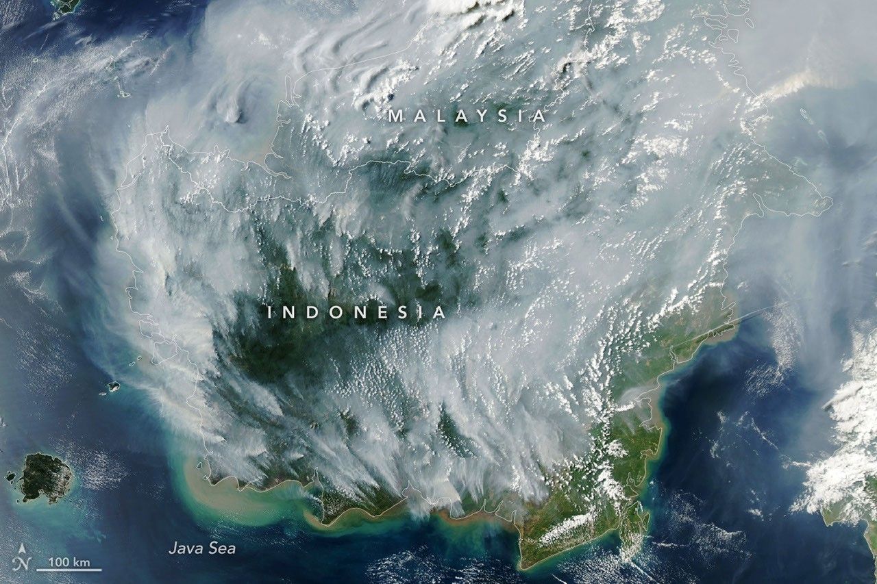
With Indonesia gripped by drought, fires are smoldering on the surface and underground.
If there were an apex predator among fires, tropical peatland fires would be a top contender. These fires, which burn in dried wetland soils, are slow-burning, highly polluting, and notoriously difficult to extinguish because they smolder at low temperatures and often burn underground through expansive deposits of peat. By one estimate, peat fires generate three times more fine particulate matter than other tropical forest fires, five times more sulfur dioxide, three times more organic carbon, and two times more methane and carbon monoxide.
Fire season was underway in Indonesia when the MODIS (Moderate Resolution Imaging Spectroradiometer) on NASA's Aqua satellite captured this image on September 1, 2026. In the map on the right, each red dot depicts one “fire detection.” A fire detection is a pixel in which the sensor and an algorithm determined there were thermal anomalies indicative of fire. Multiple detections can be generated by a single fire.
Peat fires are a recurring challenge in Indonesia, which is home to about 36 percent of the world's tropical peatlands. When parched by drought, the archipelago's peat landscapes have become unrelenting infernos on several occasions over the past three decades, with fires producing blankets of smoke for weeks on end and upending daily life for millions of people.
While fires occur in Indonesia every year, previous El Niño years—1997 and 2015 especially—produced the most extreme burning in recent decades. The climate pattern, assessed by NOAA as present and strengthening in August, typically leads to sharp reductions in rainfall in Indonesia, particularly when combined with a positive phase of the Indian Ocean Dipole, which was also present.
"Indonesia is only about three weeks into its fire season, but we're seeing fire activity track sharply upward, similar to 2015," said Robert Field, a Columbia University researcher who developed a tool called the Global Fire Weather Database that produces experimental, real-time fire weather forecasts. "The strong El Niño is making the dry season drier over the fire-prone parts of the country and exacerbating burning—just as we anticipated it would," he said. In 2015, after burning for more than three months, Indonesia's fires had released 1.75 billion tons of greenhouse gas equivalents—more than Japan emits in a year. As of September 2, Indonesia's 2026 fires, having burned for about a month, have released roughly 10 percent as much as the 2015 fires.
As in 2015, Indonesia was in the midst of a severe and widespread drought in summer 2026. About 90 percent of the country received little to no rainfall in early August, according to data from the Indonesian meteorological agency. Normally, it's too wet for fires to spread through underground peat deposits in Kalimantan, Sumatra, and Papua, but they can in dry conditions. "Surface fires are less of a concern, but when fires get underground, they just won't stop," Field said. "They'll keep burning until the rains come in October or November."
The Indonesian government uses NASA and NOAA observations from the MODIS and VIIRS sensors to track active fires in near-real-time. Indonesia's Ministry of Forestry MODIS- and VIIRS-based fire-monitoring platform SiPongi, for instance, tallied 946 hotspots on August 31, 2026.
However, it's difficult for MODIS and VIIRS to detect fires through thick smoke or clouds, within the forest understory, or underground in peat deposits. When Indonesian fires become the most intense, the number of fires recorded by VIIRS or MODIS can actually decrease. "The worst smoke events, paradoxically, can be the hardest to observe from space with MODIS and VIIRS," said Mark Cochrane, an ecologist at the University of Maryland Center for Environmental Science who has conducted field research on peat fires in Indonesia for nearly a decade.
The large-scale construction of irrigation canal